Thursday, April 15, 2010
Meteor Show Over Iowa
TOM ALEX TALEX@DMREG.COM • April 15, 2010
A television station in Madison, Wis., has received pictures from a viewer that purport to be fires started by an exploding meteor that streaked across the Midwest sky Wednesday night.
WISC-TV at Madison says a viewer believes the fires were started by meteorites striking a wooded area near Blue River in southwest Wisconsin.
Kimberly Kienitz, of Avoca, Wis., told The Des Moines Register today, that she was leaving a first responders training session for EMS workers with a friend Wednesday night when the night sky turned green. "It was bright green and there was a huge ball of fire."
She went home and started following accounts of the meteor on Facebook, then learned there was a possible impact site. She headed that direction, she said, and took photographs of small fires in the woods. Kienitz said the meteorites apparently landed in a roughly one mile area between Blue River and Boscobel.
"People asked me if I saw pieces of it," Kienitz said. "I told them, no, it was dark and we were in the woods."
John Haase, a meteorologist with the National Weather Service in the Quad Cities, said witnesses reported hearing a crackling sound. If that's true, he said, the meteor might have been some 30 feet wide, making it a roughly once-a-year event for the planet.
Susan Curtis, a secretary with the Richland County, Wis., Sheriff's Office, said she heard a loud boom overhead like thunder, but it lasted much longer. "It just kept rumbling. I thought something hit behind our house," she said.
Similar reports came from a wide area of the Midwest.
It was moving from west to east.
Meteorologist Haddie McLean, of WISC-TV, said the National Weather Service likely would be investigating the viewer's report.
"Well before it reached the horizon, it broke up into smaller pieces and was lost from sight," officials said on the Weather Service website. The fireball was seen across at least five states, according to the weather service: Iowa, northern Missouri, Illinois, Indiana and southern Wisconsin.
Another Weather Service official said Minnesota can be added to that list.
"Several reports of a prolonged sonic boom were received from areas north of Highway 20, along with shaking of homes, trees and various other objects including wind chimes," the weather service website says.
The National Weather Service in the Quad Cities appeared to capture a portion of the smoke trail on Doppler radar. It appeared "as a thin line extending across portions of Grant and Iowa Counties in Wisconsin, positioned nearly 88 miles north-northeast of Davenport at an elevation of just over 24,000 feet. Meteorologist Haase said it may have exploded at about 6,000 feet. "Usually they vaporize but there are reports that chucks hit the ground." For the record: A meteoroid is a small, solid body traveling through space. A meteor is a meteoroid heating up as it enters earth's atmosphere, causing a luminous phenomenon. A meteorite is a piece of a relatively large meteoroid that survives the earth's atmosphere and strikes the surface.
Friday, April 9, 2010
Funnel Cloud Friday
Posted: 11:07 am EDT May 6, 2009Updated: 11:10 pm EDT May 6, 2009
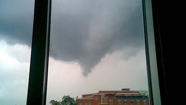
CHARLOTTE, N.C. -- Viewers snapped photos of a funnel cloud that formed Wednesday evening near the campus of UNC Charlotte. One of them, Lacy Beatty, told Channel 9 Eyewitness News that the funnel moved over the campus in northeast Charlotte.
"It started moving really slow, then started getting tighter at the bottom and getting lower and lower," said Beatty.
Other viewers also sent Eyewitness News pictures of the same funnel cloud swooping over northeast Charlotte Wednesday evening.
Channel 9 chief meteorologist Steve Udelson reviewed radar images from Live Early Warning Doppler 9. Udelson said the radar showed a bow echo, which is characteristic of rotating winds, moving over UNC Charlotte at the same time that Beatty said she saw the funnel cloud.
"We're fortunate that the funnel cloud didn't touch down," said Udelson.
Thunderstorms moved through the Charlotte area on Wednesday and tornado warnings were issued in several counties. All of the warnings expired with no reports of any significant damage.
Thursday, April 8, 2010
Storms weaken as they move northeast
WCNC News
Posted: Thursday, Apr. 08, 2010
Tornadoes may have touched down in Lincoln and Catawba Counties, meteorologists say, though the storm system that caused them is weakening as it moves northeast this evening.
Jeffrey Taylor, with the National Weather Service said the bulk of the line of storms is pushing through the greater Charlotte area now, but is weaker than an hour or two ago.
Meteorologists could see rotation indicative of tornadoes on radar, but haven't received confirmation reports from the ground.
"A lot of these tornadoes that form in this environment, they form quickly and are maybe be on the ground five or 10 minutes. They're quick and often in rural areas, so they're hard to confirm."
The fire chief of Lawndale said his department was responding to reports of a tree that fell on a mobile home.
Emergency responders said there were reports of trees down there and in the town of Lattimore, which is also in western Cleveland County.
Earlier tornado warnings had been issued for a wide swath -- Mecklenburg, Cabarrus, Gaston and Lincoln Counties. Most of those have been downgraded, but forecasters believe parts of those counties will still get severe weather.
Showers and storms will be coming to an end around midnight and much cooler air will begin to rush in. Overnight low temperatures will drop down into the upper 40s by Friday morning.
Read more: http://www.charlotteobserver.com/2010/04/08/1364972/tornado-watch-in-effect.html#ixzz0kZTYZllL
Tuesday, April 6, 2010
Turn Back the Clock Twister Tuesday
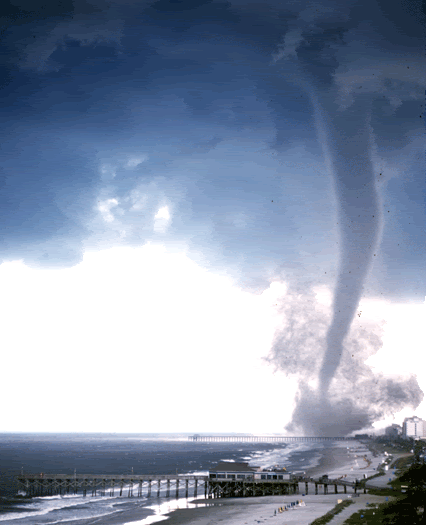
During the late afternoon of July 6, 2001, two tornadoes occurred in portions of North Myrtle Beach and Myrtle Beach, South Carolina. A Special Marine Warning was issued for the coastal waters adjacent to Horry County at 3:38 pm. This warning was in effect due to large thunderstorms drifting south along the coastline. The potential for waterspouts was mentioned in the warning.
The first reports were actually of flooding rains and came in around 4:00 pm. At 4:20 pm, the Myrtle Beach police department informed us they were checking on reports of damage, however at this time it was believed the damage was caused by lightning rather than wind.
Between 4:25 and 4:30 pm, several reports of tornadoes in Myrtle Beach were received at the National Weather Service. A Tornado Warning was issued for Horry County at 4:33 pm. At 4:34 pm, weather observations from the Myrtle Beach airport included mention of a tornado moving southwest near the end of the runway. Tower personnel reported seeing the funnel surrounded by a debris cloud.
Many people saw this tornado, and excellent video was obtained by several TV stations and by dozens of vacationers. Their videos show the funnel moving slowly across the beachfront surrounded by a varying cloud of debris and dust. Flashes of light were visible as power lines arced in the winds. Damage was widespread across portions of Myrtle Beach and a small portion of North Myrtle Beach. Luckily, there were NO serious injuries and no deaths directly attributable to the storm.
A preliminary damage assessment was performed during the evening of July 6th and revealed damage to many buildings, signs, utility poles, and vehicles. The magnitude of the damage suggests F2 strength for the tornado, which corresponds to peak wind speeds of 113 to 157 mph. Many automobiles and multi-story motels had their windows blown out. Several structures had damage to their roofs and stucco walls, and one wooden structure had its roof completely removed. Power lines were down and some large billboards were damaged. The power of the wind was very evident when several vehicles were actually flipped over by the tornadoes, including two tourist trolleys. The most concentrated damage occurred in the vicinity of the Myrtle Beach pavilion, although more spotty damage occurred for miles north along the coastline.
This storm occurred during the busy Fourth of July week when nearly 400,000 vacationers are at Myrtle Beach. Reports indicated up to thirty-six people were taken by ambulance to area hospitals for only minor injuries. Damage from this tornado is preliminarily estimated at $8,000,000. Damage to automobiles accounts for over $1,000,000 of that total. At the height of the storm, 4,000 Myrtle Beach residents were without power.
More Tornado Pictures Here
Sunday, April 4, 2010
Tornado Week Begins on Weather Channel
Line Up
Monday, April 05
8:00pm EDT: Storm Stories - "Tornado Chasers"
8:30pm EDT: Storm Stories - "May '08 Midwest Outbreak"
Tuesday, April 06
8:00pm EDT: Storm Stories - "Aurora Tornado"
8:30pm EDT: Storm Stories - "Murfreesboro Tornado"
Wednesday, April 07
8:00pm EDT: Storm Stories - "Atlanta Tornado"
9:00pm EDT: Storm Riders
Thursday, April 08
8:00pm EDT: Storm Stories - "Tornado Chasers"
8:30pm EDT: Storm Stories - "May '08 Midwest Outbreak"
Friday, April 09
2:00pm EDT: Storm Stories- "Lone Grove Tornado"
2:30pm EDT: "St. Louis Tornado"
Saturday, April 10
8:00pm EDT: Storm Stories - "Red River Rescue"
8:30pm EDT: Storm Stories - "Blizzard Transplants"
Saturday, April 3, 2010
Friday, April 2, 2010
5 Days Ago....
Here is a recap of Sundays Storms...
slyttle@charlotteobserver.com
Another team from the Weather Service is in Gaston and Mecklenburg counties today, to determine if the storm which caused damage in Belmont and northwest Mecklenburg also was a twister.
The meteorologists said the storm in Spencer was an EF1 on the enhanced Fujita scale, which measures severity of tornadoes. That is the second-weakest of six categories, but an EF1 can contain winds of up to 100 mph.
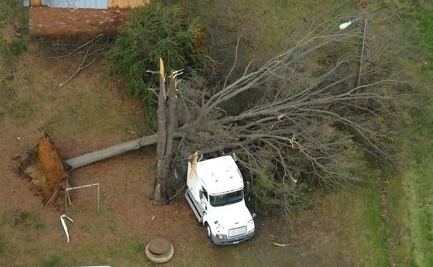
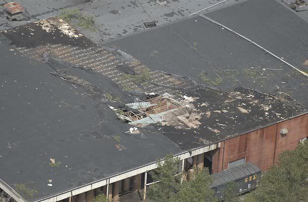
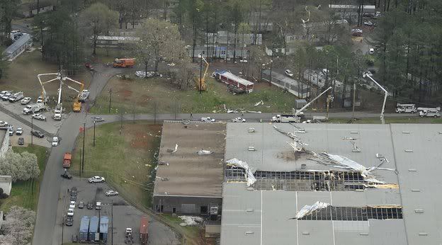
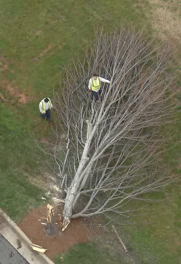
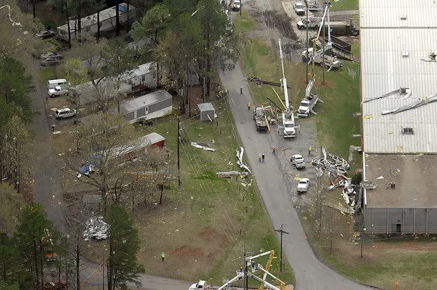
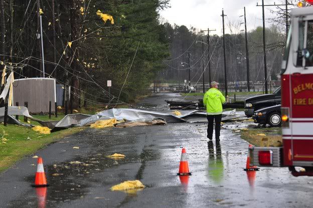
The storm in Gaston County toppled trees and peeled a massive metal roof from an industrial building in Belmont. The Spencer storm, which later crossed into Davidson County, triggered strong winds that tore off parts of the facade of a Food Lion grocery store and tossed it across a parking lot.
The good news: No injuries directly caused by the storms were reported.
There were no reports of serious flooding, even though nearly 2 inches of rain was reported in an eight-hour span at Charlotte/Douglas International Airport. A flood advisory was issued overnight for Mallard Creek near UNC Charlotte, when gauges indicated the creek had spilled out of its banks. But creek water levels had dropped by this morning.
While National Weather Service investigators check the locations of possible tornadoes, other people will be busy today with the aftermath of the storms.
Downed trees are being cut, and power crews are finishing work on repairs to utility lines. Another busy group today is auto insurance adjusters, as large hail was reported in a number of locations Sunday afternoon and evening.
Not all areas were affected. For example, southeast Mecklenburg County, Matthews and southwest Union County largely escaped damaging weather. But most areas were impacted by either hail or damaging winds.
The storm came in three waves, with the first thunderstorm producing the most damage.
First storm
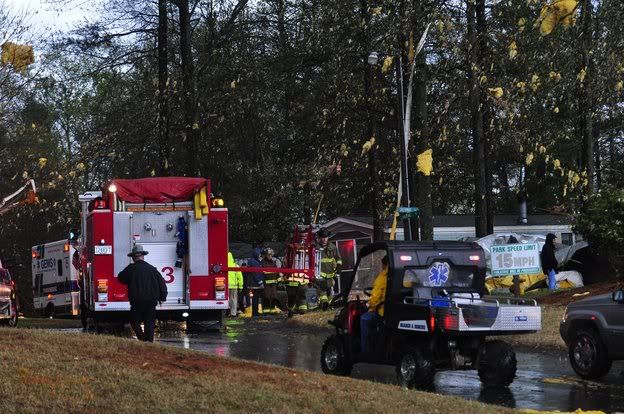
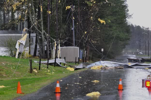
The first round arrived in the area about 5:30 p.m. In far western Mecklenburg, sheds were wrapped around utility poles, trees fell onto homes, power lines were down and a roof was ripped off a building by that band of storms.
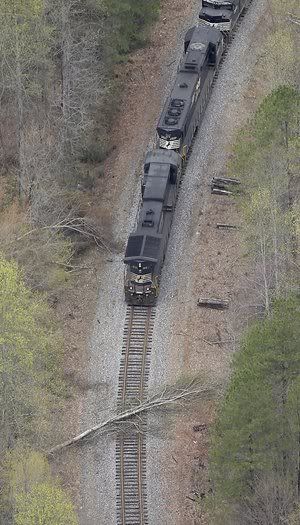
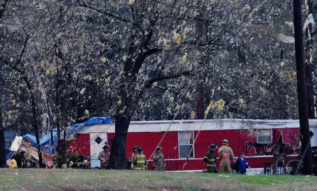
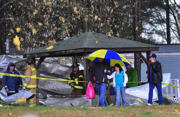
Before reaching Mecklenburg, the storm walloped the Belmont area of Gaston County, blowing the roof off Parkdale Fiber Distribution Center. The roof ended up in trees and on the ground, along with ribbons of yellow foam insulation scattered like confetti. One piece of crumpled metal slightly smaller than a fire truck lay on the ground between two mobile homes. Trees were dropped throughout the Belmont-Mount Holly area.
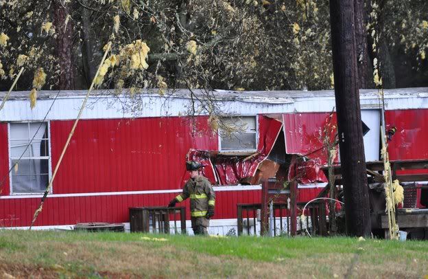
A resident at the Wylie Overlook mobile home park was taken to a hospital for observation after flying debris from the Parkdale building damaged her mobile home, authorities said. She was expected to be fine. All but the damaged mobile homes are still habitable, Gaston County emergency officials said.
As night fell, firefighters were still on the scene clearing debris, and power company employees worked to restore electricity. Metal strips blew from the warehouse's tattered roof when the wind gusted.
Mitch Carmichael was in his mobile home at the park watching the Duke-Baylor NCAA basketball game when he felt the structure shake and thought a tornado was approaching. "I sure as hell heard it," he said. "It sounded like a mini-Hugo," referring to Hurricane Hugo, which struck the area in 1989.
The power went out and Carmichael heard pine cones and other debris pelting the trailer. "I'm still shaking," he said an hour later.
David Kuhrt of Belmont was inside his mobile home when he saw something strange: "It was just pouring. Then it all of a sudden stopped raining. I looked outside and saw what looked like a cloud of red dirt coming down."
He rushed a relative's five children into a bathroom and waited. "There's no really safe place in a trailer," he said. He heard debris flying and hitting the trailer and when the storm passed, he found a baseball-sized hole punched through an outside wall.
Scott Roberts was at a nearby Wal-Mart off Wilkinson Boulevard when he stepped out for a cigarette. He looked up and saw rotating clouds. "It was the whole general sky, not just one place. It was scary." About that time, his wife called from the mobile home park and told him a tornado had just passed over.
The storm continued northeast into Mecklenburg County, primarily in western Mecklenburg and northwestern Charlotte, as swirling wind knocked over trees and power lines -- damaging properties in the 1700 block of Brim Street and the 1600 block of Wildwood Drive, Charlotte Fire Department spokesman Rob Brisley said.
Those locations were off Sam Wilson and Moores Chapel roads.
Brisley said that countywide, about a dozen homes suffered minor damage from the storm, and two suffered significant damage. No one in Mecklenburg was injured as a result, but the Red Cross was helping at least a dozen people arrange temporary shelter.
That storm swept through quickly, about 40 mph, into Cabarrus and Rowan counties, dropping quarter-sized hail and heavy rain and whipping up fast winds. Hail was reported across the area at different times through the evening from Plaza-Midwood to Mooresville.
As the storms roared up I-85, damage was reported in Spencer, where a Food Lion store on Salisbury Avenue suffered serious damage and a sign at nearby Kerr Drugs was destroyed, authorities said.
Across the street, two large trees uprooted and fell on a nearby home and other trees dropped over roads and onto power lines. Witnesses say the parking lot of the N.C. Transportation Museum was damaged.
The storm then crossed into Davidson County.
Multiple mobile homes were overturned in Linwood, outside of Lexington, and at least one person was reported injured, according to CNN. Another apparent tornado was reported on the ground in High Point, where at least 20 homes were reported damaged, the weather service said.
A number of residents in Rowan and Davidson counties took photos or video of an apparent tornado.
Second storm
Shortly before 8 p.m., a cluster of thunderstorms that had caused considerable damage in the Greenville-Spartanburg area moved into Gaston County. Emergency management officials said a tornado might have touched down near Crowders Mountain, although no serious damage was reported.
That storm touched off another tornado warning for Mecklenburg County,
It dropped large hail in the area near Northlake Mall, and also in Huntersville. As the storm moved into Cabarrus County, residents about 5 miles west of Concord reported the ground covered with hail.
This time, however, there were no reports of tornadoes in Mecklenburg County.
Third storm
Yet another severe thunderstorm reached Charlotte shortly before 10 p.m., after dropping large hail and producing wind gusts of 50 mph in York County.
This storm was responsible for blowing down several large limbs and some small trees in southwest Charlotte, near Bramblewood Road and West Arrowood Road, near the Bramblewood soccer complex. Hail up to 1 3/4 inches in diameter was reported in the Myers Park area.
A few additional storms reached the area overnight, but they were considerably weaker.
The Associated Press contributed.
Read more: http://www.charlotteobserver.com/2010/03/28/1342800/tornado-warning-downgraded-to.html#ixzz0jusVioJq
Warm weather coming for Easter weekend
The warmest weather so far this year is arriving just in time for the Easter weekend, forecasters say.
However, they can't rule out the possibility that a shower might not affect the area late in the day on Easter Sunday.
A large high pressure system is forecast to develop this week across the eastern United States. It will produce sunny skies with increasingly warmer temperatures, say forecasters.
Tuesday's high temperatures in the upper 60's will yield to highs in the middle 70's Wednesday.
The sunshine is forecast to continue Thursday through Saturday, with daily highs in the lower 80's. It hasn't reached 80 degrees in Charlotte since last Oct. 23.
Easter Sunday is forecast to dawn partly cloudy and mild, with sunrise temperatures in the middle 50's -- above average for that time of year. However, a cold front will be approaching the Carolinas by Sunday, so showers could spread into the region by late in the day.
The advance outlook for the week after Easter -- when most public school students in the area will be on spring break -- calls for mild temperatures, with daily highs in the 70's. Some rain is possible Monday.
Hurricane outlook: 'Extreme season'
Forecasters say weather patterns are conspiring to produce a busy hurricane season in the Atlantic and Caribbean, with one meteorologist predicting more than a half-dozen storms coming ashore in 2010.
This follows a quiet 2009 season, in which the U.S. mainland was not touched by any of the giant storms.
"This year has the chance to be an extreme season," says Joe Bastardi of Pennsylvania-based AccuWeather, who correctly predicted 2009's quiet season and the record-setting snowfall this winter along the East Coast. "It is certainly much more like 2008 than 2009, as far as the overall threat to the United States' East and Gulf coasts."
Don't cancel your August or September beach vacations quite yet.
Not all the forecasts are in. For example, the National Hurricane Center's seasonal prediction won't come until late May. And some forecasters plan to fine-tune their outlooks later this spring, when conditions become a bit clearer.
Besides, long-range hurricane forecasts have been unreliable in the past.
But meteorologists say they are getting better at predicting months ahead of time, as they learn more about the inter-relationships of various trends responsible for storm formation.
Perhaps no forecast is more closely watched than that from the Colorado State University team of Philip Klotzbach and William Gray. In December, they predicted 11 to 16 named storms this season, with three to five becoming major hurricanes.
Their next update is due in about a week.
AccuWeather's Bastardi is calling for 15 named storms, with two or three major hurricanes (Category 3 or stronger on the Saffir-Simpson scale of 1 to 5) making landfall on the U.S. coast.
Both those predictions are considerably above the nine named storms in 2009.
That compares to 15 named storms in 2008, when five systems made landfall on the Gulf Coast.
The 2008 hurricane season had a major impact on oil refinery operations in Louisiana and Texas, triggering a gasoline shortage in Charlotte and other parts of the Southeast in late September of that year.
The reasons most commonly cited for the 2010 forecast:
A weakening of El Nino, the condition that creates warmer-than-normal surface water temperatures in the eastern Pacific. In El Nino years, such as 2009, a persistent west-to-east wind blows across the southern United States. That wind tends to disrupt the formation of tropical systems in the Atlantic and Caribbean.
Water temperatures in the tropical Atlantic that are warmer than last summer. Tropical systems get their power from warm water.
Weaker winds off the west coast of Africa. That, forecasters say, will lessen the chances of dust from the Sahara Desert blowing into the Atlantic and disrupting the formation of tropical storms and hurricanes. Such a condition was present last year.
Steve Pfaff, a meteorologist at the National Weather Service's office in Wilmington, addressed the hurricane outlook last week, when talking to South Carolina emergency management directors at Litchfield Beach, S.C.
"I would say we're going to have a much more active hurricane season," Pfaff said.
Bastardi says he has found a parallel in this year's conditions with those of 1964, 1995 and 1998. Each of those years produced above-average numbers of hurricanes affecting the U.S. coast.
In 1998, Hurricane Bonnie made landfall near Wilmington as a weak Category 3 storm, causing $1 billion in damage.
The 1995 season included Tropical Storm Jerry, which caused severe flooding in the Charlotte area that left three people dead and millions of dollars in damage. That season also included Hurricane Opal, which made landfall on the Florida panhandle and brought damaging winds as far north as the Charlotte area. The (Myrtle Beach) Sun News contributed.
Read more: http://www.charlotteobserver.com/2010/03/28/1341428/hurricane-outlook-extreme-season.html#ixzz0jupkymmH
