Thursday, April 15, 2010
Meteor Show Over Iowa
TOM ALEX TALEX@DMREG.COM • April 15, 2010
A television station in Madison, Wis., has received pictures from a viewer that purport to be fires started by an exploding meteor that streaked across the Midwest sky Wednesday night.
WISC-TV at Madison says a viewer believes the fires were started by meteorites striking a wooded area near Blue River in southwest Wisconsin.
Kimberly Kienitz, of Avoca, Wis., told The Des Moines Register today, that she was leaving a first responders training session for EMS workers with a friend Wednesday night when the night sky turned green. "It was bright green and there was a huge ball of fire."
She went home and started following accounts of the meteor on Facebook, then learned there was a possible impact site. She headed that direction, she said, and took photographs of small fires in the woods. Kienitz said the meteorites apparently landed in a roughly one mile area between Blue River and Boscobel.
"People asked me if I saw pieces of it," Kienitz said. "I told them, no, it was dark and we were in the woods."
John Haase, a meteorologist with the National Weather Service in the Quad Cities, said witnesses reported hearing a crackling sound. If that's true, he said, the meteor might have been some 30 feet wide, making it a roughly once-a-year event for the planet.
Susan Curtis, a secretary with the Richland County, Wis., Sheriff's Office, said she heard a loud boom overhead like thunder, but it lasted much longer. "It just kept rumbling. I thought something hit behind our house," she said.
Similar reports came from a wide area of the Midwest.
It was moving from west to east.
Meteorologist Haddie McLean, of WISC-TV, said the National Weather Service likely would be investigating the viewer's report.
"Well before it reached the horizon, it broke up into smaller pieces and was lost from sight," officials said on the Weather Service website. The fireball was seen across at least five states, according to the weather service: Iowa, northern Missouri, Illinois, Indiana and southern Wisconsin.
Another Weather Service official said Minnesota can be added to that list.
"Several reports of a prolonged sonic boom were received from areas north of Highway 20, along with shaking of homes, trees and various other objects including wind chimes," the weather service website says.
The National Weather Service in the Quad Cities appeared to capture a portion of the smoke trail on Doppler radar. It appeared "as a thin line extending across portions of Grant and Iowa Counties in Wisconsin, positioned nearly 88 miles north-northeast of Davenport at an elevation of just over 24,000 feet. Meteorologist Haase said it may have exploded at about 6,000 feet. "Usually they vaporize but there are reports that chucks hit the ground." For the record: A meteoroid is a small, solid body traveling through space. A meteor is a meteoroid heating up as it enters earth's atmosphere, causing a luminous phenomenon. A meteorite is a piece of a relatively large meteoroid that survives the earth's atmosphere and strikes the surface.
Friday, April 9, 2010
Funnel Cloud Friday
Posted: 11:07 am EDT May 6, 2009Updated: 11:10 pm EDT May 6, 2009
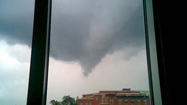
CHARLOTTE, N.C. -- Viewers snapped photos of a funnel cloud that formed Wednesday evening near the campus of UNC Charlotte. One of them, Lacy Beatty, told Channel 9 Eyewitness News that the funnel moved over the campus in northeast Charlotte.
"It started moving really slow, then started getting tighter at the bottom and getting lower and lower," said Beatty.
Other viewers also sent Eyewitness News pictures of the same funnel cloud swooping over northeast Charlotte Wednesday evening.
Channel 9 chief meteorologist Steve Udelson reviewed radar images from Live Early Warning Doppler 9. Udelson said the radar showed a bow echo, which is characteristic of rotating winds, moving over UNC Charlotte at the same time that Beatty said she saw the funnel cloud.
"We're fortunate that the funnel cloud didn't touch down," said Udelson.
Thunderstorms moved through the Charlotte area on Wednesday and tornado warnings were issued in several counties. All of the warnings expired with no reports of any significant damage.
Thursday, April 8, 2010
Storms weaken as they move northeast
By Cleve R. Wootson Jr. and NewsChannel 36
WCNC News
Posted: Thursday, Apr. 08, 2010
Tornadoes may have touched down in Lincoln and Catawba Counties, meteorologists say, though the storm system that caused them is weakening as it moves northeast this evening.
Jeffrey Taylor, with the National Weather Service said the bulk of the line of storms is pushing through the greater Charlotte area now, but is weaker than an hour or two ago.
Meteorologists could see rotation indicative of tornadoes on radar, but haven't received confirmation reports from the ground.
"A lot of these tornadoes that form in this environment, they form quickly and are maybe be on the ground five or 10 minutes. They're quick and often in rural areas, so they're hard to confirm."
The fire chief of Lawndale said his department was responding to reports of a tree that fell on a mobile home.
Emergency responders said there were reports of trees down there and in the town of Lattimore, which is also in western Cleveland County.
Earlier tornado warnings had been issued for a wide swath -- Mecklenburg, Cabarrus, Gaston and Lincoln Counties. Most of those have been downgraded, but forecasters believe parts of those counties will still get severe weather.
Showers and storms will be coming to an end around midnight and much cooler air will begin to rush in. Overnight low temperatures will drop down into the upper 40s by Friday morning.
Read more: http://www.charlotteobserver.com/2010/04/08/1364972/tornado-watch-in-effect.html#ixzz0kZTYZllL
Tuesday, April 6, 2010
Turn Back the Clock Twister Tuesday
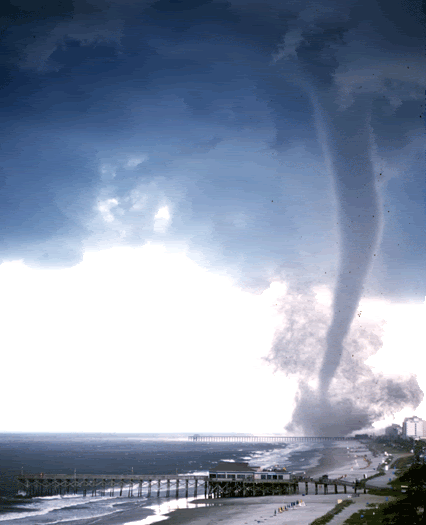
During the late afternoon of July 6, 2001, two tornadoes occurred in portions of North Myrtle Beach and Myrtle Beach, South Carolina. A Special Marine Warning was issued for the coastal waters adjacent to Horry County at 3:38 pm. This warning was in effect due to large thunderstorms drifting south along the coastline. The potential for waterspouts was mentioned in the warning.
The first reports were actually of flooding rains and came in around 4:00 pm. At 4:20 pm, the Myrtle Beach police department informed us they were checking on reports of damage, however at this time it was believed the damage was caused by lightning rather than wind.
Between 4:25 and 4:30 pm, several reports of tornadoes in Myrtle Beach were received at the National Weather Service. A Tornado Warning was issued for Horry County at 4:33 pm. At 4:34 pm, weather observations from the Myrtle Beach airport included mention of a tornado moving southwest near the end of the runway. Tower personnel reported seeing the funnel surrounded by a debris cloud.
Many people saw this tornado, and excellent video was obtained by several TV stations and by dozens of vacationers. Their videos show the funnel moving slowly across the beachfront surrounded by a varying cloud of debris and dust. Flashes of light were visible as power lines arced in the winds. Damage was widespread across portions of Myrtle Beach and a small portion of North Myrtle Beach. Luckily, there were NO serious injuries and no deaths directly attributable to the storm.
A preliminary damage assessment was performed during the evening of July 6th and revealed damage to many buildings, signs, utility poles, and vehicles. The magnitude of the damage suggests F2 strength for the tornado, which corresponds to peak wind speeds of 113 to 157 mph. Many automobiles and multi-story motels had their windows blown out. Several structures had damage to their roofs and stucco walls, and one wooden structure had its roof completely removed. Power lines were down and some large billboards were damaged. The power of the wind was very evident when several vehicles were actually flipped over by the tornadoes, including two tourist trolleys. The most concentrated damage occurred in the vicinity of the Myrtle Beach pavilion, although more spotty damage occurred for miles north along the coastline.
This storm occurred during the busy Fourth of July week when nearly 400,000 vacationers are at Myrtle Beach. Reports indicated up to thirty-six people were taken by ambulance to area hospitals for only minor injuries. Damage from this tornado is preliminarily estimated at $8,000,000. Damage to automobiles accounts for over $1,000,000 of that total. At the height of the storm, 4,000 Myrtle Beach residents were without power.
More Tornado Pictures Here
Sunday, April 4, 2010
Tornado Week Begins on Weather Channel
Tornado Week begins April 4 - 10 on the Weather Channel. The Weather Channel has put up a cool website previewing the programming. You can check it out here at http://intothetornado.com/
Line Up
Line Up
Monday, April 05
8:00pm EDT: Storm Stories - "Tornado Chasers"
8:30pm EDT: Storm Stories - "May '08 Midwest Outbreak"
Tuesday, April 06
8:00pm EDT: Storm Stories - "Aurora Tornado"
8:30pm EDT: Storm Stories - "Murfreesboro Tornado"
Wednesday, April 07
8:00pm EDT: Storm Stories - "Atlanta Tornado"
9:00pm EDT: Storm Riders
Thursday, April 08
8:00pm EDT: Storm Stories - "Tornado Chasers"
8:30pm EDT: Storm Stories - "May '08 Midwest Outbreak"
Friday, April 09
2:00pm EDT: Storm Stories- "Lone Grove Tornado"
2:30pm EDT: "St. Louis Tornado"
Saturday, April 10
8:00pm EDT: Storm Stories - "Red River Rescue"
8:30pm EDT: Storm Stories - "Blizzard Transplants"
Subscribe to:
Comments (Atom)
